«««< HEAD
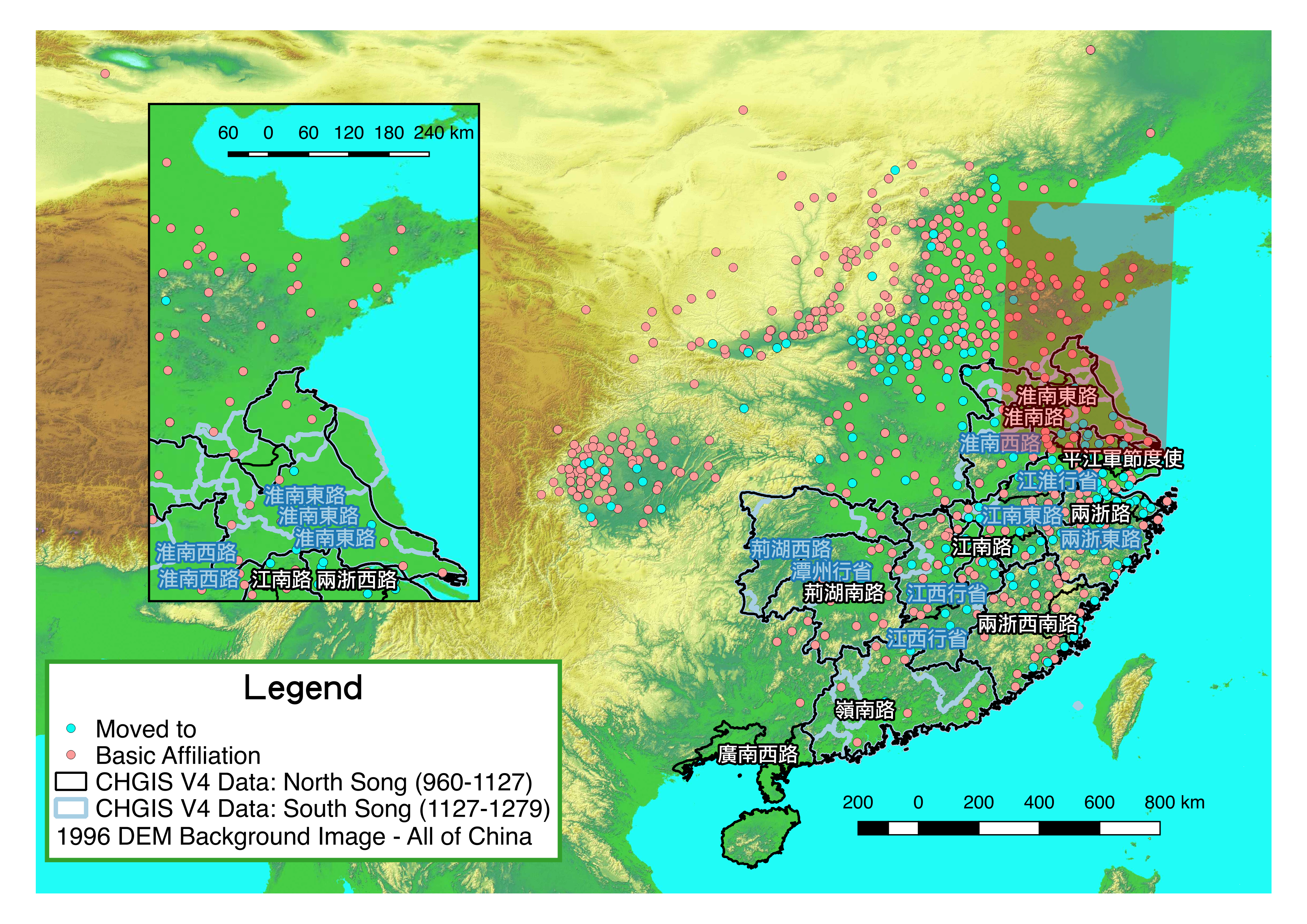
Location Distribution of Civil's Basic Affiliation and Moved-to Destinations in Song Dynasty of China (960-1279)
— A Simple Study Case Combing China Biographical Database with China Historical GIS Database Using Python, DB Browser for SQLite and Quantum GIS
=======
A Simple Study Case Combing China Biographical Database with China Historical GIS Database Using Python, DB Browser for SQLite and Quantum GIS
origin/master
Databases
- China Biographical Database (CBDB):a freely accessible relational database with biographical information about approximately 360,000 individuals as of April 2015, primarily from the 7th through 19th centuries.
- China Historical GIS Database (CHGIS):was launched in January 2001 to establish a database of populated places and historical administrative units for the period of Chinese history between 221 BCE and 1911 CE.
Software
- DB Browser for SQLite: open source tool compatible with SQLite, works for OS X.
- Quantum GIS (QGIS):Open Source Geographic Information System (GIS) licensed under the GNU General Public License. QGIS is an official project of the Open Source Geospatial Foundation (OSGeo).
Procedure
1. Download related Databases
- cbdb_sqlite.db from CBDB
-
Time-Series Province Boundaries in POLYGONS (25 MB) from CHGIS
- 1996 DEM Background Image - All of China in RASTER (12 MB) from CHGI
2. Use DB Browser for SQLite to View Database (cbdb_sqlite.db) and determine required information
-
Information Needed Here
- Civil’s Birth Year and Death Year: to determine if a certain civil was born and died within duration of Song dynasty (960-1279)
- Civil’s Person ID (w/ names)
- Civil’s Address:
- X and Y coordinates
- Address type: such as basic affiliation (籍贯), Moved to (遷住地), Ancestral Address (祖籍), Burial Address (葬地) and etc.
- Here I used
- Type 1: Basic Affiliation
- Type 2: Moved To
-
Three Related Tables
-
BIOG_MAIN (Table A): A.c_personid,A.c_name, A.c_name_chn, A.c_birthyear, A.c_deathyear
-
BIOG_ADDR_DATA (Table B): B.c_personid, B.c_addr_type, B.c_addr_id
-
ADDR_XY (Table C): C.c_addr_id, C.x_coord, C.y_coord
-
3. Write a Python Script Subtracting Civil’s Information in Database
- Python Script: Sqlite3 is embedded within Python
<<<<<<< HEAD

=======
>>>>>>> origin/master
#!/usr/bin/env python
# encoding=utf-8

# *----------------------------*
# Title: cbdb-harvard-person-in-dyn.py
# by hessiatrix@gmail.com, Mar 14, 2017
# *----------------------------*

import sys
from os import path
import sqlite3

conn = sqlite3.connect(r"/Users/hessiatrix/Desktop/cbdb-harvard/cbdb_sqlite.db")
cursor = conn.cursor()

# 从表A根据年份选出宋代期间的人物,得到id和姓名;根据id从表B得出地理信息;根据c_add_id从表C得到xy座标
# Duration of North Song dynasty: 960-1126;South Song: 1127-1279 (靖难1127.03.20)
cursor.execute('select A.c_personid,A.c_name, A.c_name_chn,B.c_addr_type,B.c_addr_id,C.x_coord,C.y_coord from BIOG_MAIN A, BIOG_ADDR_DATA B, ADDR_XY C where A.c_personid = B.c_personid and B.c_addr_id = C.c_addr_id and A.c_birthyear >= ? and A.c_deathyear <= ?',(960,1279))
person_info = cursor.fetchall()

with open('song-person-xy-event.txt','w') as output:
	output.write("c_personid,c_name,c_name_chn,c_addr_type,c_addr_id,x_coord,y_coord\n")
	for row in person_info:
		print row
		output.write("%i,%s,%s,%i,%i,%f,%f\n" % (row[0],row[1].encode('utf-8'),row[2].encode('utf-8'),row[3],row[4],row[5],row[6] ))
output.close()


# FILE END
conn.close()
- Output Example
c_personid,c_name,c_name_chn,c_addr_type,c_addr_id,x_coord,y_coord
1,An Dun,安惇,1,100430,106.791330,30.477690
14,Chao Duanyan,晁端彥,5,100429,115.146840,35.924000
14,Chao Duanyan,晁端彥,1,100658,114.335660,34.818340
17,Chen Anshi,陳安石,1,11478,112.785721,34.840869
17,Chen Anshi,陳安石,14,11725,114.345497,36.098343
20,Chen Qizong,陳起宗,1,12696,120.733788,31.646582
……
4. Use QGIS to Visualize
- Open New Project
- Add Delimited Text Layer: txt
- Drag shapefile v4_time_prov_pgn_utf.shp and geotiff file v4_dem.tif in to main window
- Adjust Layer Styling according to need and personal preferences: Lock and Unlock Layers
- Output
- Zoom current window to preferred scale
- Project-> New Print Composer
- Follow this tutorial: Making a Map: QGIS Tutorials and Tips

